Coastal Resiliency
What Is Coastal Resiliency and Why Does It Matter?
“Coastal Resiliency” is defined as the ability to rebound quickly after a coastal storm and the ability to withstand shocks and stresses while maintaining essential functions. It also includes preventing or minimizing storm-related damages, ensuring public safety, protecting natural and recreational resources and maintaining a sustainable community.
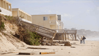
While Nor’easters occur more frequently and can last multiple tide cycles, the most extreme coastal flooding is the result of hurricanes, and the recurrence interval of hurricane strikes in the vicinity of East Hampton is about 17 years. Major hurricane strikes have devastated Montauk in 1938, 1954 (Carol), 1960 (Donna), 1991 (Bob) and 2012 (Sandy).
- During the next 30 years, the chance of experiencing a flood event with a magnitude similar to that of the Hurricane of ’38, at least once, is about 60%.
- Climate change is likely to increase the frequency and intensity of hurricanes.
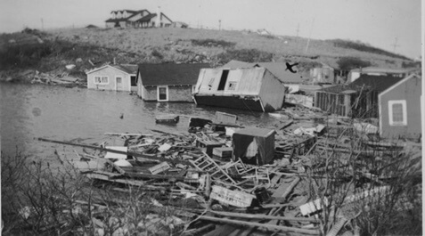
Old Montauk Fishing Village After 1938 Hurricane
The rate of sea level rise is predicted to increase significantly in the future. NYS projects sea level rise of between 12-30 inches over the next 30 years. Although recent reports indicate sea level rise may be greater and occur more rapidly as a result of different factors including greenhouse gas emissions, sea and air temperature, glacial ice melt and oceanographic effects.
COASTAL ASSESSMENT RESILIENCY PLAN (CARP)
To address rising seas and increasing storm impacts, the Town of East Hampton developed the Coastal Assessment and Resiliency Plan (CARP) — a long-term roadmap for adapting to coastal change and protecting vulnerable community areas.
Adopted in 2022 with support from the NYS Department of State, CARP guides local actions on erosion, flooding, and infrastructure resilience. CCOM helped secure funding for the plan’s development.
• TOEH Coastal Assessment and Resiliency Plan Information
• CARP, 2021
Montauk’S Vulnerability And Resiliency Recommendations
A recent study of Montauk’s vulnerability has determined five coastal areas at risk due to the threat of climate change, sea-level rise, and coastal erosion: Montauk Downtown, Fort Pond, Ditch Plains, Montauk Harbor, Culloden/Sound View Drive. Each differ in the type and extent of coastal risk and the imminence of significant future impact as outlined below. A mix of three specific strategies is required to address Montauk’s vulnerability and to plan for and achieve coastal resilience and adaptation. These are:
- Managed Retreat: Managed withdrawal from coastal areas, most often accommodated by adaptive land use and managed relocation.
- Accommodate: Allowing flood inundation to occur, but protecting infrastructure, property, and natural resources from damage through permanent and temporary measures implemented on an ongoing basis.
- Protect: A range of interventions designed to hold back flooding from inundating developed areas and to prevent erosion and loss of land
CARP Public Workshop on Montauk Focus Areas (VIDEO 9/9/2020)
CCOM’s CALl TO ACTION
CCOM is calling for the following 5 steps to be actioned immediately.
- Immediate Review of East Hampton Town’s Building and Zoning Flood Protection Codes
- Implementing the New York State Community Risk and Resilience Act (CRRA) guidance within the Town, specifically: a) consideration of sea-level rise in the establishment of a Town-specific Design Flood Elevation (DFE); b) consideration of implications for existing building height zoning regulations; and c) regulation of Coastal AE zones as coastal high hazard areas
- Beach nourishment as a near-term, intermediate measure to reduce beach erosion and preserve dunes
- Downtown Montauk FIMP (Fire Island to Montauk Point) beach nourishment of approximately 600,000 cubic yards of ocean dredged sand in 2022 followed by additional nourishment every four years of up to 400,000 cubic yards for a minimum of 15 years to be paid (in part by the Town) and to include beach nourishment at Ditch Plains.
- Implementation of Managed Retreat Planning
- Committee of stakeholders must be formed to establish retreat adaptation plans for Montauk’s downtown. Solutions should be looked at under multiple lenses of environmental sustainability, safety, and economic impact and implemented through market-based tools such as Transfer Development Rights (TDR) programs, tax credits, and other incentives to encourage people to voluntarily move away from vulnerable areas and encourage the protection and conservation of natural shorelines.
- Ensure Municipal Funding Is Secured to Address Short and Long-Term Resiliency Goals
- Identify and incorporate current and future resilience public works cost obligations
- Identify specific resilience project costs (e.g., beach nourishment, roadway improvements, property buyouts)
- Develop a comprehensive funding strategy
- Use Town’s Community Preservation Fund to purchase property dedicated for Managed Retreat and conversion to conservation land and/or to meet a federal match. CPF land acquisition planning should be aligned with the Town’s coastal resilience and adaptation goals.
- Increase public coastal resiliency education and outreach
- Facilitate through community meetings, development, and distribution of informational brochures and materials, issuance of surveys to gather feedback, direct mailings, FAQ handouts, and publicly accessible websites with relevant information.